Gallery
About this campground
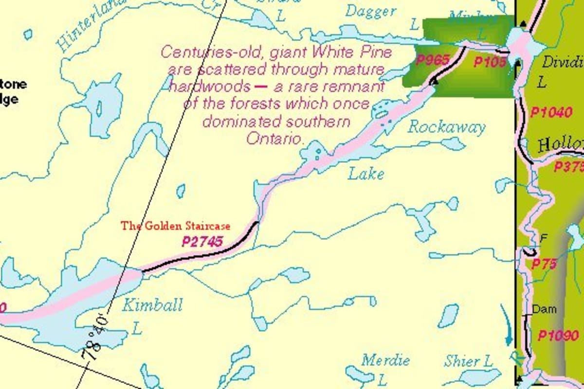
Technical Guide: Hwy 35 north of Dorset Right on Kawagama road and follow to end. Northeast through Kawagama lake P 274 m into Kimball lake East through Kimball lake P 2743 beside Kimball Creek into Rockaway Lake East on Rockaway Lake P 914 m into Minkey Lake East on Minkey Lake P 91 m into Dividing Lake Return by same route Special Comments: We entered via Access point 14 and not Kawagama as the route describes. Both Bear and Livingstone Lakes are heavy cottage areas so make sure you bring potable water for the first part of the trip. The 320m portage from Bear to Kimball runs along a creek that can easily be paddled, I imagine only in really low water conditions would you might need to portage. There are a few campsites on Kimball, one really nice site on Aubrey Island so if you want to make this a weekend trip and need to camp early the first night it is doable. The first two thirds of the 2780m portage into Rockaway are flat and very easy, there is a steady climb the last third but not too bad. There are several rough cabins on Rockaway and an extra campsite not marked on the Chrismar Map Algonquin 3. The site at the portage into Minkey is the one we used and far nicer than the other marked site. Although the site we stayed on is within the park boundries, it is not reservable. This route is not as well used as some of the other Algonquin routes and the trees are impressive. You have to aquire your permit at the Marine shop in Dorset.
How to get to Rockaway and Dividing Lakes
-
Head towards the nearest highwayUse your preferred navigation app to reach the main highway leading to the region.
-
Exit towards Dorset, OntarioTake the signed exit and follow local road signs for Rockaway and Dividing Lakes.
-
Follow local access roadProceed carefully on the access road; conditions may vary seasonally.
-
Arrive at the entranceLook for the Rockaway and Dividing Lakes entrance sign and check in if required.
How to book Rockaway and Dividing Lakes
-
Check availabilityOn the Rockaway and Dividing Lakes page, select your dates to check availability.
-
Review detailsReview campsite details, rules, pricing, and cancellation policy before booking.
-
Complete bookingProceed to checkout, provide guest details, and confirm your reservation.
-
Receive confirmationYou will receive a booking confirmation with check-in instructions via email.